This is a project to develop a web service "Web Geoscience Library" that can share geoscience teaching contents maps on the Web, and a QGIS plug-in "Geoscience library creation tool" that creates teaching contentes map data for the Web Geoscinence Library on QGIS.
Background
1. Importance of geoscience education
For science education, it is very important to learn scientific perspectives and ideas through the practice of observation and exploration experience.
In particular, for Japan, with many environmental and natural disasters, the penetration of disaster education to the general public and the training of leaders are urgent issues.
2. Utilization of GIS in geoscience education
GIS (Geographic Information System) can be used effectively in geoscience education.
Summarize of observed and surveyed information, modeling for exploration, information accumulation, etc. can be performed using GIS.
Since the data is stored digitally, it is easy to collect, process, transfer and reuse survey and research results, so it can be used effectively in various fields.
However, commercial GIS is expensive, and few people have the skills to use GIS and develop teaching materials.
As a result, it tends to be the operation education of GIS software in the educational setting, and the current situation is that the use of GIS for geoscience education has not yet spread.
Therefore, development of an inexpensive GIS application environment using open source GIS specialized for geoscience education is desired.
For example, for earth science education and earth science related workers, specialists (leaders) in environmental disaster prevention field, and students.
3. Goal of this project
In this project, we will develop a GIS utilization environment specialized for geosciences education using open source GIS that has been widely spread in recent years.
In particular, our goal is to support procedure of geological mapping work from field survey to geological map creation.
User
- Teacher or scientist who is engaged in earth science education and earth science related work
- Specialists (leaders) in the field of environmental disaster prevention and students who aim to be specialists
Situation
- Summary of field training for student
- Lecture materials or reports for teacher
- Documents or reports for scientist
Feature
- Support for procedure of map creation work from field survey to subject map drawing
- High scalability by using open source and open data
- Project management function
Usage tools and system flow
Use the tools in the following figures.
Software uses open software (OSS) as much as possible, and applies an add-on program as needed.
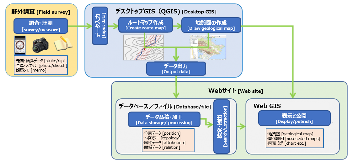
Field survey tools
- Digital clino meter (Geoclino for iPhone by AIST): record current position and strike/dip data of the outcrop
- Camera : record photo of the outcrop
- Field note :make a note of the appearance and shape of the outcrop.
- Others (Hammer, sample bag etc.)
Desktop GIS (QGIS) : Geoscience contents & maps creation tool
- Desktop GIS application (QGIS) and "Geoscience library creation tool" plug-in : create scenario map and subject map for geoscinece library.
Web site : Geoscience information sharing & publishing tool
- Database (MySQL) and WebGIS application (MySQL, PHP, JavaScript, Leafret) : share and publish geoscience scenario and subject map data.
For tWebGIS application, we provides wordpress plug-in that can be implemented on the wordpress site.